Fuss-free Bromo and Tumpak Sewu: A Travel Log
Last January I spent four days in East Java, particularly in these regions: Surabaya — Malang — Lumajang. What follows is a selection of breathtaking views of rolling hills, mountains, pretty sunrises and waterfalls, collaged below. I wanted to share what was a pretty fuss-free adventure we had and it was all thanks to our tour guide Mas Wayan from Lepas Suntuk. You can check them out via this link or their Instagram.

First and foremost, I believe what made it very fuss-free and enjoyable especially for an introvert and a planner like myself is the fact that we took a private tour. It really was the best decision despite paying a bit more — but I’d do that for my sanity anytime. For costs, I recommend reaching out to them directly as it may vary depending your location, timing, number of people, et cetera.
Our itinerary: 2 days of tour and based ourselves in Surabaya
Day 1: Arrival at Surabaya
I flew into Surabaya from Singapore and arrived pretty early in the morning. Made my way to our hotel at Aston Inn Jemursari (verdict: it was great, affordable, great service (!), but a bit far from the city).

My friend, Dennise, came in by 7-hour train from Banyuwangi so we met up for late lunch at Layar — pictured first above. We ordered Bandeng Sambal Matah and Kepiting Asap Kraton for our mains. I have to give Layar, the most-recommended restaurant by my friends, two thumbs up, it was so so good. Just that I was not prepared for how fancy the restaurant looked lol (I was definitely underdressed).

The rest of the day was us getting stuck in some traffic, a late-night “trotoar” snack (meaning snacks you buy on the side road and typically not very hygienic but known to be extremely delicious) that was a Tahu Telor (I was not a fan), and power-napped our way before we were picked up at midnight to make our way to the Jeep basecamp for Mount Bromo!
Day 2: Mount Bromo (and wider Tengger Semeru National Park)
- 12–2 am: Surabaya to Jeep base camp in Malang
- 2–3.30 am: off-road with a Jeep ride to the sunrise point
- 3.30–4.30 am: breakfast near the sunrise point
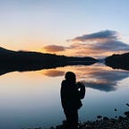
- 4.30–6 am: sunrise watching
- 6 am onwards: exploring the national park

Our driver picked us up from the hotel at 12 AM and it took about 2 hours to get to the Jeep basecamp. To access the sunrise viewpoint at Mount Bromo you would need to go through some off-roading. It was not very clear what the view was like because it was literally 3 AM when we set off but spoiler alert: it was a VERY bumpy path and we were shaken left and right. No one warned us about this Jeep ride so here we are, warning you. It was bad but not that bad; anyway, it was the only way to access this area. Although, do read through this post to find other ways you can cut this excruciating 45mins ride short.

After the Jeep ride, we arrived at the viewpoint area called Bukit Cinta. You will find a full row of houses selling simple meals and souvenirs, as well as shops renting out jackets, earmuffs, and gloves. It was said that the temperature can reach <10 degrees Celcius but once the sun rises it warms up pretty fast.
I saw some people with proper puffer jackets but I think I managed just fine with layering myself with one long sleeve, a fleece jacket, and another thin jacket. We were shaken from the Jeep ride and had not had anything (not even a proper dinner lol) so we devoured instant noodles and Dennise who happened to be a big fan of ginger, ordered Wedang Jahe (do try them out if you never did!).
Alright here is a quick geographical download — Mount Bromo is located in a wider area that is called Bromo Tengger Semeru National Park, and it is MASSIVE. It covers some 800km and from what the guide told us, over 3 regencies with active volcanoes.


So post-sunrise-watching, we spent about 3 hours exploring the national parks with few spots that include: Widodaren, Pasir Berbisik, Padang Savana, and Bukit Teletubbies, all pictured below.


This leg of the tour was that tiring that once me and my friend reached our stay, Bobocabin at Coban Rando, we ate lunch, checked in, slept the entire afternoon, and had suki for dinner but then it started pouring, then we went back in, talked, and slept til the next morning.
Verdict of the cabin stay: overall good! The amenities were pretty comprehensive, very comfortable, and clean, but just a bit small. Plus, if we were not this tired we could have explored the area but we did not. Next time I might book the family-size cabin for a more comfortable stay, and might also be better to stay for two nights so you can really get the “staycation” experience.

Day 3: Tumpak Sewu Waterfall (and supposedly Kapas Biru)
- 5.30 — 9 am: Coban Rando to Lumajang, one of the entry points to Tumpak Sewu Waterfall
- 9 — 11 am: down to the Tumpak Sewu Waterfall itself, a viewpoint at Goa Tetes, and went back up (it was raining so heavily when we got to Goa Tetes so we headed back fearing floods)
- 11 am — 12 pm: light lunch by the waterfall entrance
- 12 pm onwards: made our way back to Surabaya (around 5 hour's ride including a stop at a local souvenir shop)

From the car park, we made our way first to a shoe rental place just before the entrance. You would need to actually walk through some water currents (you will see below), and mini waterfalls. Overall, it was a wet terrain. The anti-slip shoes were Rp 20,000 (less than USD 1.50) to rent, and remember to keep some spare changes as well because you would need another Rp 5,000 (less than USD 1) to enter the toilet if you want to get changed after.

This “path” is mostly staircases so you just need the stamina for that. It seems quite safe even for me who is a hugely risk-averse individual so I can guarantee this is totally doable. Wear shorts if you don’t want to get soaked and uncomfortable because one of the paths does require you to go through a pretty strong and high (just below my knee and I am about 165cm) water current.

Additionally, the weather can be quite moody. It was all sunny and blue but very quickly the rain poured and it was very windy I thought the storm was gonna come anytime soon when we reached Goa Tetes. That said, we made a U-turn, cut our trip short by two destinations (Goa Tetes and supposedly Kapas Biru), and headed back to Surabaya. The day after, we departed Surabaya.

Here’s one more geographical download. See the below photograph courtesy of photographer Rolands Varsbergs via Unsplash, there is a mountain backdrop which is often pictured when one talks about Tumpak Sewu. The waterfall is connected to Mount Semeru (don’t ask me how I am not a geography student haha). Just two days after we visited, there was a lava flood at the Waterfall which came from Semeru, some tourists at the waterfall base were even trapped for a bit. Our guide also told us that it happened a couple months back for 14 days. I guess this is just nature being nature.
My overall verdict and observation
- Weather plays a big role, so do come in with that factored in and maybe lower your expectations hahaha
- Mt Bromo sunrise point is very accessible in that there is no real “hike”. Our viewpoint was very steep though, but still manageable
- It can get VERY crowded but no choice. Do avoid the holiday season at all costs, I asked my tour guide and he said: Christmas + NY and Idul Fitri see the most crowd
- Carry small cash with you as you may need to pay to enter toilets and buy water or snacks
- Always ASK the prices first before you buy anything. Especially if you look like a foreigner — a surcharge may apply without you knowing! Although we did encounter some places that put their menu and prices up which we thought to be very fair of them

- You will see a lot of warning and “be careful” signs (and insurance company logos lol)— of the area being disaster-prone like landslides and flooding. Which is very true. I was quite wary at first but I guess… it is part of the game and we just gotta pray. The locals know best (I believe) so I just do what they say (with a pinch of salt too)
- Tipping — I don’t know the local custom for this but apparently, our tour guide only earned about 10% of what we paid for the trip (so the tour provider runs on a commission basis with their guides). We gave him another 10% of that roughly as a tip by the end of the trip! I think it’s not a super must but just a nice courtesy
- People are very kind and warm. Even when we reached non-touristy areas on our way, I still felt the same!
- We are very, very thankful for our guide, Mas Wayan who is also our photographer throughout the trip (in the wefie below) and our driver (who we did not catch the name sadly)!

More advice on what to pack
For Bromo > warm clothes. I managed with 1 long sleeve, 1 fleece jacket, 1 normal jacket. For the bottom, I wore leggings but may be more comfortable if you have any fleeced hiking pants!
For Tumpak Sewu > quick dry top because you’ll get sprayed by the water anyway and the wind can be quite strong). I just wore my running gear LOL + shorts because you’ll have to walk through some wet terrains, and you don’t wanna walk with wet heavy bottoms. Anti-slip, crocs-like shoes can also be helpful if you already have one.
Throughout, I only brought a small backpack for our water and some snacks!
I hope this post is useful for those wanting to explore more of Indonesia’s nature. It is a truly beautiful country (that I am glad to call home).